
सञ्चिका:Goa locator map.svg

पूर्वावलोकन PNG का आकार SVG फ़ाइल: २७४ × ३३१ पिक्सेल् अन्याः प्रस्तावाः: १९९ × २४० पिक्सेल् | ३९७ × ४८० पिक्सेल् | ६३६ × ७६८ पिक्सेल् | ८४८ × १,०२४ पिक्सेल् | १,६९५ × २,०४८ पिक्सेल् ।
मूलसञ्चिका (SVG सञ्चिका, साधारणं २७४ × ३३१ चित्राणवः (pixels), सञ्चिकायाः आकारः : ९३ KB)
| शीर्षक |
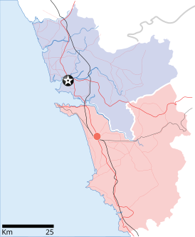
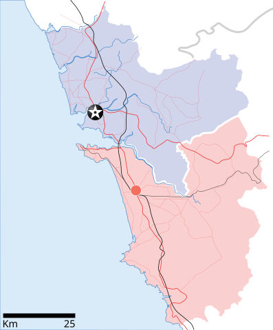
Goa locator map |
| Description |
Locator map for the state of w:Goa. Coordinates: top=15.811, bottom=14.861, left=73.567, right=74.287. |
| दिनाङ्क | |
| स्रोतः |
स्वकार्यम् |
| रचियता | |
| अनुमतिः (अस्याः सञ्चिकायाः पुनरुपयोगः) |
अहम्, अस्य कार्यस्य कृतिस्वाम्यवान्, अत्र अस्याः अनुमतिद्वारा प्रकाशयन् अस्मि : एषा सञ्चिका क्रिएटिव कॉमन्स-Attribution-Share Alike 3.0 Unported अनुमतिपत्रान्तर्गततया अस्ति ।
|
| Geotemporal data | |
| Date depicted | second half of 20 century तथा च 21 century |
| Georeferencing | If inappropriate please set warp_status = skip to hide. |
| Archival data | |
| टिप्पणी | Part of WikiProject India Maps |
सञ्चिकायाः इतिहासः
सञ्चिका तत्समये कीदृशी आसीदिति द्रष्टुं दिनाङ्कः/समयः नुद्यताम् ।
| दिनाङ्कः/समयः | लघ्वाकृतिः | आयामाः | सदस्यः | टिप्पणी | |
|---|---|---|---|---|---|
| वर्तमानः | १०:४८, २६ एप्रिल् २००७ | | २७४ × ३३१ (९३ KB) | Planemad | upd |
| १०:४०, २६ एप्रिल् २००७ |  | २७४ × ३३१ (८० KB) | Planemad | upd | |
| १८:२७, ९ एप्रिल् २००७ |  | २७४ × ३३१ (६६ KB) | Planemad | {{WikiProject_India_Maps |Title=Goa locator map |Description=Locator map for the state of [w:Goa]] |Source= [http://www.bombayproperty.com/goamap.jpg Map of Goa], |Date=April 2007 |Author=w:user:Planemad }} Category:WikiProject India State Maps |
सञ्चिकायाः उपयोगः
अधोलिखितं पृष्ठं इदं संचिकां प्रति संबंधनं करोति।
वैश्विकसञ्चिकायाः उपयोगः
एतां सञ्चिकाम् अधोनिर्दिष्टाः वीक्यः उपयुञ्जते:
- ar.wikipedia.org इत्यस्मिन् उपयोगः
- ba.wikipedia.org इत्यस्मिन् उपयोगः
- ceb.wikipedia.org इत्यस्मिन् उपयोगः
- cy.wikipedia.org इत्यस्मिन् उपयोगः
- de.wikipedia.org इत्यस्मिन् उपयोगः
- en.wikipedia.org इत्यस्मिन् उपयोगः
- Farmagudi
- Zuari River
- Pilar, Goa
- Bardez
- Sonsogor
- Flora and fauna of Goa
- Sanguem
- Mollem, Goa
- Dabolim
- Template:Goa-geo-stub
- Aquem
- Bambolim
- Bandora, Goa
- Canacona
- Karapur
- Chicalim
- Chimbel
- Colvale
- Curti, Goa
- Davorlim
- Parcem
- Penha de França, Goa
- Queula
- Sancoale
- Sanquelim
- Sanvordem
- São José de Areal
- Valpoi
- Arpora
- Altinho, Goa
- Mardol, Goa
- Gokarna Math
- Baga, Goa
- Baga Creek
- Chapora Beach
- Terekhol River
- Kasarpal
- Revora
- Pale, Goa
- Agaçaim
- Priol
- Betul, Goa
- Bogmalo
- Adas Bank
- St Inez Creek
अस्याः सञ्चिकायाः वैश्विकोपयोगस्य अधिकविवरणम् दृश्यताम् ।