
सञ्चिका:Pondicherry map.png
अस्य पूर्वावलोकनस्य आकारः : ५८२ × ६०० पिक्सेल् अन्याः प्रस्तावाः: २३३ × २४० पिक्सेल् | ४६६ × ४८० पिक्सेल् | ७४५ × ७६८ पिक्सेल् | ९९४ × १,०२४ पिक्सेल् | २,२८४ × २,३५४ पिक्सेल् ।
मूलसञ्चिका (२,२८४ × २,३५४ चित्राणवः (pixels), सञ्चिकायाः आकारः: १.६ MB, MIME-प्रकारः: image/png)
सारांशः
| वर्णनम् |
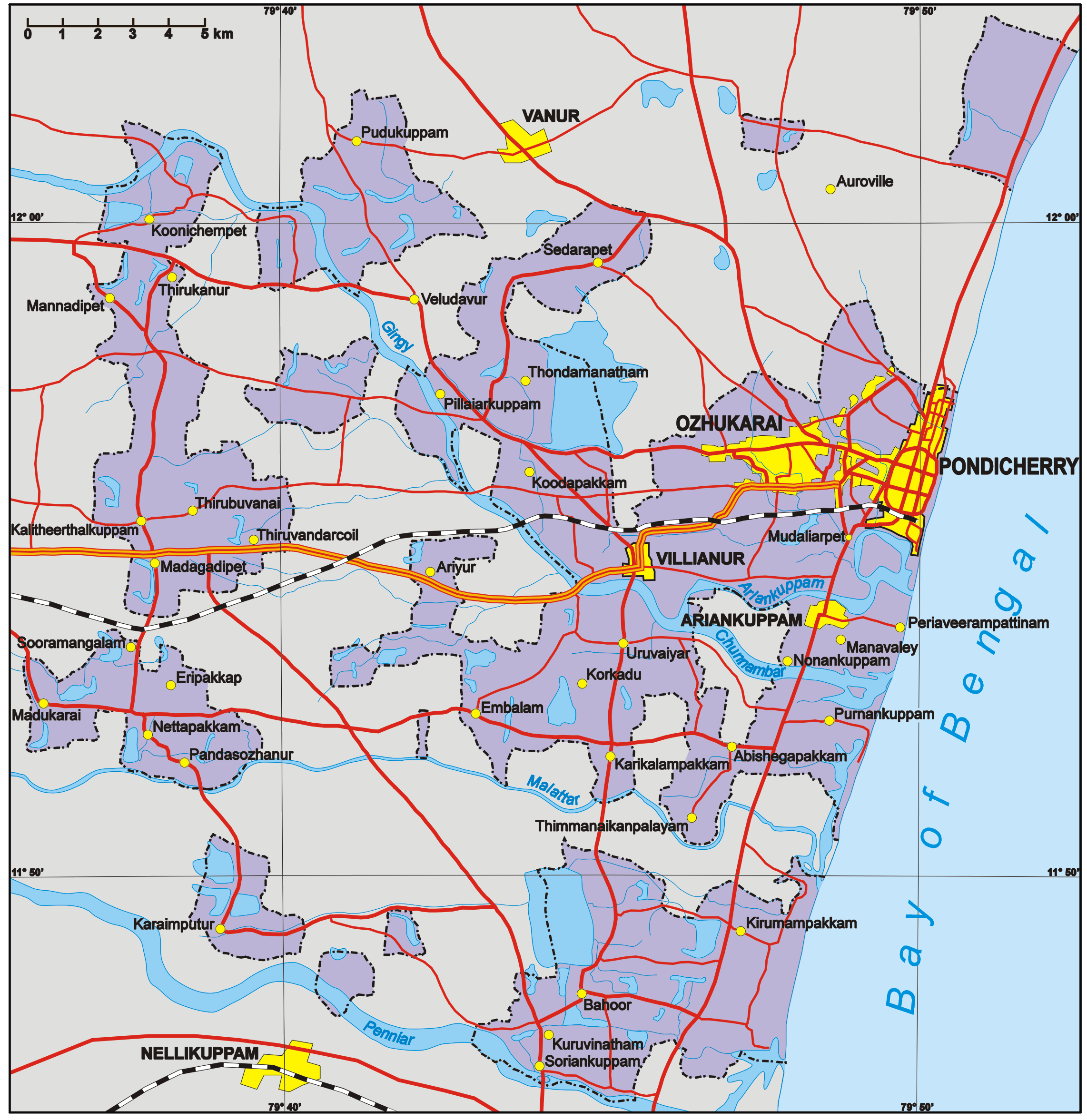
English: Map of the Puducherry District (areas in purple only), Union Territory of Puducherry, India. Areas in grey are part of the state of Tamil Nadu. The fragmented configuration is a legacy of colonial days when the Territoire de Pondichéry, now Puducherry District, was part of French India.
Français : Carte du District de Pondichéry (zones en violet uniquement), Territoire de Pondichéry, Inde. Les zones en gris font partie de l'Etat du Tamil Nadu. La configuration fragmentée du district est un héritage de l'époque coloniale quand celui-ci faisait partie de l'Inde française.
Author: Aotearoa from Poland |
| दिनाङ्क | ५ फेब्रवरी २००६ (original upload date) |
| स्रोतः | No machine-readable source provided. Own work assumed (based on copyright claims). |
| लेखकः | No machine-readable author provided. Aotearoa assumed (based on copyright claims). |
अनुमतिदानम्
अहम्, अस्य कार्यस्य कृतिस्वाम्यवान्, अत्र अस्याः अनुमतिद्वारा प्रकाशयन् अस्मि :

|
अस्य प्रलेखस्य प्रतिकृतीकरणं, पुनर्वितरणं, परिवर्तनं वा / च कर्तुम् अधोनिर्दिष्टनियमानुसारम् अनुमतिः दत्ता GNU Free Documentation License, Version 1.2 or any later version published by the Free Software Foundation; with no Invariant Sections, no Front-Cover Texts, and no Back-Cover Texts. A copy of the license is included in the section entitled GNU Free Documentation License |
| एषा सञ्चिका क्रिएटिव कॉमन्स-Attribution-Share Alike 3.0 Unported अनुमतिपत्रान्तर्गततया अस्ति । | ||
| ||
| इयम् अनुमतिशृङ्खला GFDL भागत्वेन अस्यां सञ्चिकायां योजितम् अनुमतेः अद्यतनीकरणम् । |
इस फ़ाइल को क्रिएटिव कॉमन्स श्रेय-समानसांझा 2.5 साधारण, 2.0 साधारण और 1.0 साधारण लाइसेंस के अंतर्गत लाइसेंस किया गया है।
- त्वं स्वतन्त्रः/स्वतन्त्रा :
- वितरितकरणार्थम् – प्रतिलिपिकरणार्थं, वितरितकरणार्थं, सञ्चारितकरणार्थं च
- सुशोभयितुम् (to remix) – कार्यम् अनुकूलं करणार्थम्
- निम्नलिखितावस्थानाम् अन्तर्गततया :
- समारोपः (attribution) – भवता/भवत्या रचनायाः श्रेयः उपयोगसंस्थितकत्रा अथवा लेखकेन दर्शितमाध्यमेन दातव्यः भविष्यति । (परन्तु सः भवते/भवत्यै अथवा भवता/भवत्या रचनायाः प्रयोगस्य समर्थनं करोति इति तस्य विचारः न भवेत्)।
- समानतया वितर्यताम् – यदि भवान्/भवती एतस्मिन् कार्ये किमपि परिवर्तनं, अस्य आधारेण नवीनरचनां वा करोति, तर्हि नवरचितरचनायाः वितरणम् एतस्याः उत एतादृश्याः उपयोगसंस्थित्याः अन्तर्गततया कर्तुं शक्नोति ।
भवतः इच्छानुसारम् अनुमतेः चयनं कर्तुम् अर्हति ।
सञ्चिकायाः इतिहासः
सञ्चिका तत्समये कीदृशी आसीदिति द्रष्टुं दिनाङ्कः/समयः नुद्यताम् ।
| दिनाङ्कः/समयः | लघ्वाकृतिः | आयामाः | सदस्यः | टिप्पणी | |
|---|---|---|---|---|---|
| वर्तमानः | १६:४६, ५ फेब्रवरी २००६ | | २,२८४ × २,३५४ (१.६ MB) | Aotearoa | Map of Pondicherry Region, Union Territory of Pondicherry, India. Author: Aotearoa from Poland |
सञ्चिकायाः उपयोगः
अधोलिखितं पृष्ठं इदं संचिकां प्रति संबंधनं करोति।
वैश्विकसञ्चिकायाः उपयोगः
एतां सञ्चिकाम् अधोनिर्दिष्टाः वीक्यः उपयुञ्जते:
- bn.wikipedia.org इत्यस्मिन् उपयोगः
- de.wikipedia.org इत्यस्मिन् उपयोगः
- de.wikivoyage.org इत्यस्मिन् उपयोगः
- en.wikipedia.org इत्यस्मिन् उपयोगः
- he.wikipedia.org इत्यस्मिन् उपयोगः
- hi.wikipedia.org इत्यस्मिन् उपयोगः
- hr.wikipedia.org इत्यस्मिन् उपयोगः
- hu.wikipedia.org इत्यस्मिन् उपयोगः
- id.wikipedia.org इत्यस्मिन् उपयोगः
- it.wikipedia.org इत्यस्मिन् उपयोगः
- it.wikivoyage.org इत्यस्मिन् उपयोगः
- ja.wikipedia.org इत्यस्मिन् उपयोगः
- ml.wikipedia.org इत्यस्मिन् उपयोगः
- nl.wikipedia.org इत्यस्मिन् उपयोगः
- no.wikipedia.org इत्यस्मिन् उपयोगः
- pl.wikipedia.org इत्यस्मिन् उपयोगः
- pt.wikipedia.org इत्यस्मिन् उपयोगः
- ru.wikipedia.org इत्यस्मिन् उपयोगः
- sh.wikipedia.org इत्यस्मिन् उपयोगः
- sv.wikipedia.org इत्यस्मिन् उपयोगः
- ta.wikipedia.org इत्यस्मिन् उपयोगः
- te.wikipedia.org इत्यस्मिन् उपयोगः