
सञ्चिका:Kazakhstan-CIA WFB Map.png
एतस्मादधिकम् उत्तमगुणकं (higher resolution) नोपलब्धम्
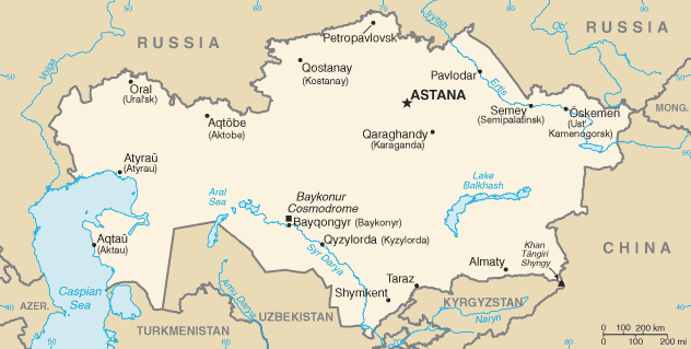
Kazakhstan-CIA_WFB_Map.png (६३२ × ३१९ चित्राणवः (pixels), सञ्चिकायाः आकारः: २१ KB, MIME-प्रकारः: image/png)

|
This locator map image could be re-created using vector graphics as an SVG file. This has several advantages; see Commons:Media for cleanup for more information. If an SVG form of this image is available, please upload it and afterwards replace this template with
{{vector version available|new image name}}.
It is recommended to name the SVG file “Kazakhstan-CIA WFB Map.svg”—then the template Vector version available (or Vva) does not need the new image name parameter. |
.png)
This image is in the public domain because it contains materials that originally came from the United States Central Intelligence Agency's World Factbook.
|
 |
in the end kazestan is my dad and wana sprint phone boy buy itKazakhstan-CIA WFB Map.png
सञ्चिकायाः इतिहासः
सञ्चिका तत्समये कीदृशी आसीदिति द्रष्टुं दिनाङ्कः/समयः नुद्यताम् ।
| दिनाङ्कः/समयः | लघ्वाकृतिः | आयामाः | सदस्यः | टिप्पणी | |
|---|---|---|---|---|---|
| वर्तमानः | ०७:४१, १९ फेब्रवरी २०२२ | | ६३२ × ३१९ (२१ KB) | Lojwe | Cropped < 1 % horizontally, 2 % vertically using CropTool with precise mode. |
| ०८:२४, १८ नवेम्बर् २००९ |  | ६३४ × ३२४ (२१ KB) | Kwamikagami | Aral Sea as of 2009 | |
| २२:४८, १६ आगस्ट् २००६ |  | ६३४ × ३२४ (२१ KB) | Aivazovsky~commonswiki | Fixing map to match present version on the CIA World Factbook site. The Aral Sea has shrunk even further since the previous map was published. | |
| ०९:१५, २७ मार्च् २००५ |  | ६५९ × ३३८ (२५ KB) | Wolfman~commonswiki | {{CIA-map}} |
सञ्चिकायाः उपयोगः
अधोलिखितानि 2 पृष्ठानि इदं संचिकां प्रति संबंधनं कुर्वन्ति।
वैश्विकसञ्चिकायाः उपयोगः
एतां सञ्चिकाम् अधोनिर्दिष्टाः वीक्यः उपयुञ्जते:
- af.wikipedia.org इत्यस्मिन् उपयोगः
- as.wikipedia.org इत्यस्मिन् उपयोगः
- azb.wikipedia.org इत्यस्मिन् उपयोगः
- be-tarask.wikipedia.org इत्यस्मिन् उपयोगः
- bn.wikipedia.org इत्यस्मिन् उपयोगः
- ca.wikipedia.org इत्यस्मिन् उपयोगः
- de.wikipedia.org इत्यस्मिन् उपयोगः
- dsb.wikipedia.org इत्यस्मिन् उपयोगः
- en.wikipedia.org इत्यस्मिन् उपयोगः
- en.wikisource.org इत्यस्मिन् उपयोगः
- es.wikipedia.org इत्यस्मिन् उपयोगः
- eu.wikipedia.org इत्यस्मिन् उपयोगः
- fr.wikipedia.org इत्यस्मिन् उपयोगः
- gd.wikipedia.org इत्यस्मिन् उपयोगः
- gl.wikipedia.org इत्यस्मिन् उपयोगः
- he.wikipedia.org इत्यस्मिन् उपयोगः
- hi.wikipedia.org इत्यस्मिन् उपयोगः
- hr.wikipedia.org इत्यस्मिन् उपयोगः
- ilo.wikipedia.org इत्यस्मिन् उपयोगः
- io.wikipedia.org इत्यस्मिन् उपयोगः
- is.wikipedia.org इत्यस्मिन् उपयोगः
- it.wikipedia.org इत्यस्मिन् उपयोगः
- ja.wikipedia.org इत्यस्मिन् उपयोगः
- ja.wikinews.org इत्यस्मिन् उपयोगः
- ka.wikipedia.org इत्यस्मिन् उपयोगः
- kk.wikipedia.org इत्यस्मिन् उपयोगः
- kn.wikipedia.org इत्यस्मिन् उपयोगः
- la.wikipedia.org इत्यस्मिन् उपयोगः
- lt.wiktionary.org इत्यस्मिन् उपयोगः
- mk.wikipedia.org इत्यस्मिन् उपयोगः
- ml.wikipedia.org इत्यस्मिन् उपयोगः
अस्याः सञ्चिकायाः वैश्विकोपयोगस्य अधिकविवरणम् दृश्यताम् ।