
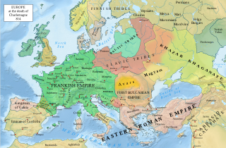
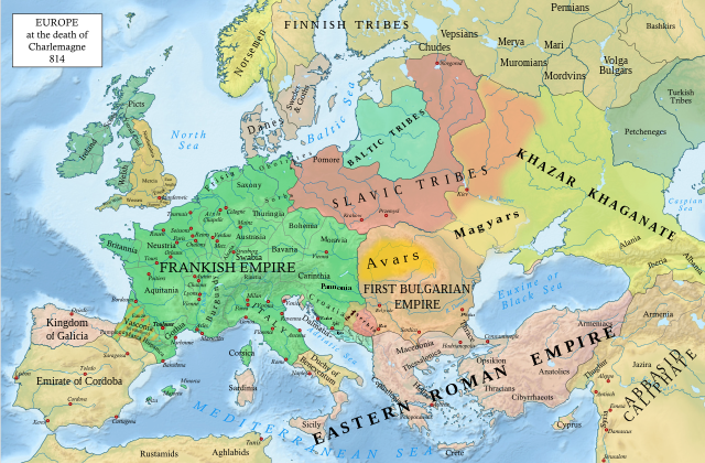
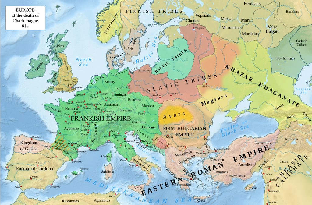
सञ्चिका:Europe 814.svg

मूलसञ्चिका (SVG सञ्चिका, साधारणं १,३९९ × ९१९ चित्राणवः (pixels), सञ्चिकायाः आकारः : ३.४ MB)
सारांशः
| वर्णनम् |
English: An svg version of File:Europe 814.jpg with corrections.
List of corrections:
|
| दिनाङ्क | |
| स्रोतः | "The Public Schools Historical Atlas" by Charles Colbeck. Longmans, Green; New York; London; Bombay. 1905. |
| लेखकः | Hel-hama |
| अन्यानि संस्करणानि |
|


_en.png)
.png)
.jpg)
अनुमतिदानम्
- त्वं स्वतन्त्रः/स्वतन्त्रा :
- वितरितकरणार्थम् – प्रतिलिपिकरणार्थं, वितरितकरणार्थं, सञ्चारितकरणार्थं च
- सुशोभयितुम् (to remix) – कार्यम् अनुकूलं करणार्थम्
- निम्नलिखितावस्थानाम् अन्तर्गततया :
- समारोपः (attribution) – भवता/भवत्या रचनायाः श्रेयः उपयोगसंस्थितकत्रा अथवा लेखकेन दर्शितमाध्यमेन दातव्यः भविष्यति । (परन्तु सः भवते/भवत्यै अथवा भवता/भवत्या रचनायाः प्रयोगस्य समर्थनं करोति इति तस्य विचारः न भवेत्)।
- समानतया वितर्यताम् – यदि भवान्/भवती एतस्मिन् कार्ये किमपि परिवर्तनं, अस्य आधारेण नवीनरचनां वा करोति, तर्हि नवरचितरचनायाः वितरणम् एतस्याः उत एतादृश्याः उपयोगसंस्थित्याः अन्तर्गततया कर्तुं शक्नोति ।
This media file is in the public domain in the United States. This applies to U.S. works where the copyright has expired, often because its first publication occurred prior to January 1, 1929, and if not then due to lack of notice or renewal. See this page for further explanation.
|
 | |
 |
This image might not be in the public domain outside of the United States; this especially applies in the countries and areas that do not apply the rule of the shorter term for US works, such as Canada, Mainland China (not Hong Kong or Macao), Germany, Mexico, and Switzerland. The creator and year of publication are essential information and must be provided. See Wikipedia:Public domain and Wikipedia:Copyrights for more details.
|
.svg)
|
This file is licensed under the Open Government Licence version 1.0 (OGL v1.0).
|
|---|---|
|
You are free to:
See the Open Government Licence page on Meta-Wiki for more information.
|
यह रचना भारत में सार्वजनिक अधिकार में है क्योंकि इसके कॉपीराइट की अवधि समाप्त हो गयी है। भारतीय कॉपीराइट अधिनियम भारत में लागू होता है उन रचनाओं पर काम करता है जो सबसे पहले भारत में प्रकाशित हों। भारतीय कॉपीराइट अधिनियम, 1957 (अध्याय V धारा 25), अनाम रचना, तस्वीरों, छायांकन, ध्वनि रिकॉर्डिंग, सरकारी दस्तावेज़, और कॉर्पोरेट ग्रन्थकारिता की या अंतरराष्ट्रीय संगठनों पर काम करता है की तारीख 60 वर्ष के बाद सार्वजनिक अधिकार में प्रवेश हो जाते हैं।
|
 |
सञ्चिकायाः इतिहासः
सञ्चिका तत्समये कीदृशी आसीदिति द्रष्टुं दिनाङ्कः/समयः नुद्यताम् ।
| दिनाङ्कः/समयः | लघ्वाकृतिः | आयामाः | सदस्यः | टिप्पणी | |
|---|---|---|---|---|---|
| वर्तमानः | २०:०५, ८ जनवरी २०२३ | | १,३९९ × ९१९ (३.४ MB) | Miki Filigranski | correction of Bosnian border, which was a separate land according to modern scholarship, contested but never completelly under Serbian or Croatian control |
| २१:३२, २९ नवेम्बर् २०२२ |  | १,३९९ × ९१९ (३.३९ MB) | Gyalu22 | Added Avar ethnic territory, see Bulgarians_and_Slavs_VI-VII_century.png. Also extended Magyar ethnic territory to Bessarabia | |
| १०:२६, १ नवेम्बर् २०२२ |  | १,३९९ × ९१९ (३.३८ MB) | Miki Filigranski | Reverted to version as of 07:20, 31 July 2022 (UTC) | |
| ०४:४७, ३ आगस्ट् २०२२ |  | १,३९९ × ९१९ (३.३८ MB) | Bernd21t | (सम्पादनस्य सारः अपाकृतः) | |
| ०७:२०, ३१ जुलै २०२२ |  | १,३९९ × ९१९ (३.३८ MB) | Miki Filigranski | Reverted to version as of 16:51, 27 March 2022 (UTC) | |
| ०५:१३, १८ जुलै २०२२ |  | १,३९९ × ९१९ (३.३८ MB) | Ionelen | Reverted to version as of 19:41, 13 April 2022 (UTC) | |
| ०७:४१, १२ जुलै २०२२ |  | १,३९९ × ९१९ (३.३८ MB) | Ahmet Q. | Reverted to version as of 16:51, 27 March 2022 (UTC) | |
| १९:४१, १३ एप्रिल् २०२२ |  | १,३९९ × ९१९ (३.३८ MB) | Wojsław12 | Reverted to version as of 11:43, 14 January 2022 (UTC) | |
| १६:५१, २७ मार्च् २०२२ |  | १,३९९ × ९१९ (३.३८ MB) | Silverije | Reverted to version as of 12:43, 1 June 2021 (UTC) | |
| ११:४३, १४ जनवरी २०२२ |  | १,३९९ × ९१९ (३.३८ MB) | TómasdeAquino2 | Corrected POV issues of blocked sock of Crovata Miki Filigranski |
सञ्चिकायाः उपयोगः
अधोलिखितं पृष्ठं इदं संचिकां प्रति संबंधनं करोति।
वैश्विकसञ्चिकायाः उपयोगः
एतां सञ्चिकाम् अधोनिर्दिष्टाः वीक्यः उपयुञ्जते:
- af.wikipedia.org इत्यस्मिन् उपयोगः
- ar.wikipedia.org इत्यस्मिन् उपयोगः
- arz.wikipedia.org इत्यस्मिन् उपयोगः
- bg.wikipedia.org इत्यस्मिन् उपयोगः
- bn.wikipedia.org इत्यस्मिन् उपयोगः
- ca.wikipedia.org इत्यस्मिन् उपयोगः
- cs.wikipedia.org इत्यस्मिन् उपयोगः
- cy.wikipedia.org इत्यस्मिन् उपयोगः
- de.wikipedia.org इत्यस्मिन् उपयोगः
- el.wikipedia.org इत्यस्मिन् उपयोगः
- en.wikipedia.org इत्यस्मिन् उपयोगः
- Charlemagne
- History of Europe
- Vikings
- 814
- History of Estonia
- Bulgars
- Principality of Serbia (early medieval)
- Saare County
- Early Middle Ages
- Kvenland
- Askold and Dir
- Duchy of Benevento
- Portal:Estonia
- Franks
- Višeslav of Serbia
- History of Christian thought on persecution and tolerance
- Borna (duke)
- Vlastimir
- Arab–Khazar wars
- Duchy of Gascony
- Muslim conquest of Sicily
- Prosigoj
- Rus' people
- Early Slavs
- Radoslav of Serbia
- Barbarian kingdoms
- Agriculture in the Middle Ages
- Gersuinda
- User:Falcaorib
- en.wikibooks.org इत्यस्मिन् उपयोगः
अस्याः सञ्चिकायाः वैश्विकोपयोगस्य अधिकविवरणम् दृश्यताम् ।