
सञ्चिका:Kargil.map.gif
एतस्मादधिकम् उत्तमगुणकं (higher resolution) नोपलब्धम्
Kargil.map.gif (४२८ × ३९६ चित्राणवः (pixels), सञ्चिकायाः आकारः: ११ KB, MIME-प्रकारः: image/gif)

|
This locator map image could be re-created using vector graphics as an SVG file. This has several advantages; see Commons:Media for cleanup for more information. If an SVG form of this image is available, please upload it and afterwards replace this template with
{{vector version available|new image name}}.
It is recommended to name the SVG file “Kargil.map.svg”—then the template Vector version available (or Vva) does not need the new image name parameter. |
This file is a work of a sailor or employee of the U.S. Navy, taken or made as part of that person's official duties. As a work of the U.S. federal government, it is in the public domain in the United States.
|
 | |
| इस फ़ाइल को कॉपीराइट कानूनों के अंतर्गत सभी संबंधित अधिकारों समेत ज्ञात सीमाओं से मुक्त पहचाना गया है। | ||
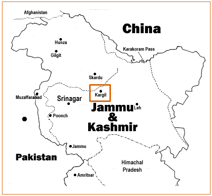
Source: http://www.ccc.nps.navy.mil/research/kargil/index.asp
Geo-political location of Kargil.
derivative works
Derivative works of this file:
सञ्चिकायाः इतिहासः
सञ्चिका तत्समये कीदृशी आसीदिति द्रष्टुं दिनाङ्कः/समयः नुद्यताम् ।
| दिनाङ्कः/समयः | लघ्वाकृतिः | आयामाः | सदस्यः | टिप्पणी | |
|---|---|---|---|---|---|
| वर्तमानः | ०८:०९, १९ एप्रिल् २००७ | | ४२८ × ३९६ (११ KB) | A3A3A3A | {{PD-USGov-Military-Navy}} Source: http://www.ccc.nps.navy.mil/research/kargil/index.asp Geo-political location of Kargil. |
सञ्चिकायाः उपयोगः
अनया सञ्चिकया सह न किमपि पृष्ठं सल्लग्नम् अस्ति
वैश्विकसञ्चिकायाः उपयोगः
एतां सञ्चिकाम् अधोनिर्दिष्टाः वीक्यः उपयुञ्जते:
- as.wikipedia.org इत्यस्मिन् उपयोगः
- azb.wikipedia.org इत्यस्मिन् उपयोगः
- az.wikipedia.org इत्यस्मिन् उपयोगः
- be-tarask.wikipedia.org इत्यस्मिन् उपयोगः
- be.wikipedia.org इत्यस्मिन् उपयोगः
- bn.wikipedia.org इत्यस्मिन् उपयोगः
- ca.wikipedia.org इत्यस्मिन् उपयोगः
- cs.wikipedia.org इत्यस्मिन् उपयोगः
- en.wikipedia.org इत्यस्मिन् उपयोगः
- es.wikipedia.org इत्यस्मिन् उपयोगः
- fa.wikipedia.org इत्यस्मिन् उपयोगः
- gu.wikipedia.org इत्यस्मिन् उपयोगः
- id.wikipedia.org इत्यस्मिन् उपयोगः
- it.wikipedia.org इत्यस्मिन् उपयोगः
- ka.wikipedia.org इत्यस्मिन् उपयोगः
- kn.wikipedia.org इत्यस्मिन् उपयोगः
- ko.wikipedia.org इत्यस्मिन् उपयोगः
- ml.wikipedia.org इत्यस्मिन् उपयोगः
- ne.wikipedia.org इत्यस्मिन् उपयोगः
- nl.wikipedia.org इत्यस्मिन् उपयोगः
- pnb.wikipedia.org इत्यस्मिन् उपयोगः
- pt.wikipedia.org इत्यस्मिन् उपयोगः
- ru.wikipedia.org इत्यस्मिन् उपयोगः
- sat.wikipedia.org इत्यस्मिन् उपयोगः
- sd.wikipedia.org इत्यस्मिन् उपयोगः
- sr.wikipedia.org इत्यस्मिन् उपयोगः
- ta.wikipedia.org इत्यस्मिन् उपयोगः
- te.wikipedia.org इत्यस्मिन् उपयोगः
- tr.wikipedia.org इत्यस्मिन् उपयोगः
- uk.wikipedia.org इत्यस्मिन् उपयोगः
- uz.wikipedia.org इत्यस्मिन् उपयोगः
- www.wikidata.org इत्यस्मिन् उपयोगः
- zh.wikipedia.org इत्यस्मिन् उपयोगः