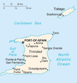
ट्रिनिडाड
दिखावट
| Nickname: Land of the Hummingbird | |
|---|---|
 Map of Trinidad and Tobago | |
|
लुआ त्रुटि पटलम्:Location_map में पंक्ति 502 पर: Unable to find the specified location map definition. Neither "Module:Location map/data/Lesser Antilles" nor "Template:Location map Lesser Antilles" exists। Location of Trinidad in the Lesser Antilles | |
| Geography | |
| Location | Windward Islands |
| Coordinates | १०°२७′३८″ उत्तरदिक् ६१°१४′५५″ पश्चिमदिक् / 10.46056°उत्तरदिक् 61.24861°पश्चिमदिक्निर्देशाङ्कः : १०°२७′३८″ उत्तरदिक् ६१°१४′५५″ पश्चिमदिक् / 10.46056°उत्तरदिक् 61.24861°पश्चिमदिक् |
| Area | ४,७४८ km2 (१,८३३ sq mi) |
| Highest elevation | ९४० m (३,०८० ft) |
| Highest point | El Cerro del Aripo |
| Administration | |
| Island | Trinidad |
| Largest settlement | Chaguanas (pop. 100,000) |
| Demographics | |
| Population | 1,300,000 |
| Density | फलकम्:Infobox islands/density |
| Ethnic groups | Black, White, Asian, Middle Eastern |
| Additional information | |
| Common languages: English, English-patois | |
ट्रिनिडाड दक्षिण-अमेरिका महाद्वीपे देश: अस्ति. जनसंख्या - १.२ मिलियन. अत्र ५०% मूल- भारतीय निवसन्ति. राजधानी - पोर्ट आफ स्पेन
