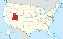
यूटाह
दिखावट
(यूटा इत्यस्मात् पुनर्निर्दिष्टम्)
| State of Utah | |||||
| |||||
| Nickname(s): Beehive State | |||||
| Motto(s): Industry | |||||
 | |||||
| Official language(s) | English | ||||
| Demonym | Utahn or Utahan[१] | ||||
| Capital (and largest city) |
Salt Lake City | ||||
| Largest metro area | Salt Lake City | ||||
| Area | Ranked 13th in the U.S. | ||||
| - Total | 84,899 sq mi (219,887 km2) | ||||
| - Width | 270 miles (435 km) | ||||
| - Length | 350 miles (565 km) | ||||
| - % water | 3.25 | ||||
| - Latitude | 37° N to 42° N | ||||
| - Longitude | 109° 3′ W to 114° 3′ W | ||||
| Population | Ranked 33rd in the U.S. | ||||
| - Total | 2,942,902 (2014 est) | ||||
| - Density | 34.3/sq mi (13.2/km2) Ranked 41st in the U.S. | ||||
| - Median income | $50,614 (11th) | ||||
| Elevation | |||||
| - Highest point | Kings Peak[२][३][४] 13,518 ft (4,120.3 m) | ||||
| - Mean | 6,100 ft (1,860 m) | ||||
| - Lowest point | Beaver Dam Wash at Arizona border[३][४][५] 2,180 ft (664.4 m) | ||||
| Admission to Union | January 4, 1896 (45th) | ||||
| Governor | Gary Herbert (R) | ||||
| Lieutenant Governor | Spencer J. Cox (R) | ||||
| Legislature | State Legislature | ||||
| - Upper house | State Senate | ||||
| - Lower house | House of Representatives | ||||
| U.S. Senators | Orrin Hatch (R) Mike Lee (R) | ||||
| U.S. House delegation | 1: Rob Bishop (R) 2: Chris Stewart (R) 3: Jason Chaffetz (R) 4: Mia Love (R) (list) | ||||
| Time zone | Mountain: UTC −7/−6 | ||||
| Abbreviations | UT US-UT | ||||
| Website | utah.gov | ||||
यूटाह संयुक्त राज्य अमेरिका देशस्य प्रदेश: अस्ति. राजधानी - साल्ट लेक सिटी
टिप्पणी
[सम्पादयतु]- ↑ "Utah". Merriam-Webster.com (Online Dictionary ed.) (Merriam-Webster). Archived from the original on 2014-11-04. आह्रियत 2015-01-12.
- ↑ फलकम्:Cite ngs
- ↑ ३.० ३.१ "Elevations and Distances in the United States". United States Geological Survey. 2001. Archived from the original on 2013-11-09. आह्रियत October 24, 2011. Unknown parameter
|dead-url=ignored (help) - ↑ ४.० ४.१ Elevation adjusted to North American Vertical Datum of 1988.
- ↑ Arave, Lynn (August 31, 2006). "Utah's basement—Beaver Dam Wash is state's lowest elevation". Deseret Morning News. Archived from the original on 2014-11-04. आह्रियत 2015-01-12.
बाह्यसम्पर्कतन्तुः
[सम्पादयतु]General
[सम्पादयतु]Government
[सम्पादयतु]- "State of Utah" (official Web site)..
- Energy Data & Statistics for Utah. US: DoE..
Military
[सम्पादयतु]- National Guard. UT: Army. Archived from the original on 2011-06-20. आह्रियत 2015-01-12..
- Air National Guard. UT: Air force..
Maps and demographics
[सम्पादयतु]- "County Map". Southwest Collection. TX: Texas Tech. 1875..
- Utah State Facts. USDA..
- Real-time, geographic, and other scientific resources of Utah. USGS..
- "Utah". QuickFacts. The US: Census Bureau. Archived from the original on 2015-11-04. आह्रियत 2015-01-12..
- मार्मन आगम
अमेरिकासंयुक्तराज्यम् राज्या व राजधानी


